Hike
| Hike is an open-source GPS Maemo application for Nokia N800/N810 internet tablet. Its purpose is to display the picture of a paper map and your GPS position on top of it. It's a useful alternative to more ambitious navigation GPS applications where good digital maps aren't readily available, such as hiking paths or exotic places. |
The picture of the map is obtained typically with a digital camera. Choose a large focal length and have the map perpendicular to the view direction, so that parallel lines on the map remain parallel on its picture. Choose a low JPEG quality to have a file not too large (a few hundred kilobytes are fine, more could force you to quit other applications). Rotations and scale discrepancies along x and y axis are taken care of.
The position mapping from GPS (latitude/longitude) to picture is based on at least two "calibration points". If you know the latitude and longitude of points which can be specified on the map picture, you can enter them numerically in decimal degrees or degree/minute/second; otherwise, you can use your GPS position as you walk. Calibration points should define an area as broad as possible.
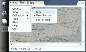
Screenshot

|
This snapshot was created in the development scratchbox where GPS isn't available. GPS provides also the altitude. Click the image to have a larger screenshot. |
Features overview
Hike has the following features:
- Can load any jpeg or png image
- Stores calibration points in a file with a
.calsuffix associated with the image file - Remembers the last map image and loads it at startup
- Displays the GPS position and altitude, in normal view or full screen mode
- Choice between metric and imperial units, and decimal or deg/min/sec angles
- Can record tracks where fluctuations are smoothed out and save them in GPX format
- Detailed GPS information with estimated position uncertainties
Install
If you read this page on your internet tablet, click this link to install the latest version of Hike. Otherwise, you can download a .deb file below and open it on your tablet.
Releases
2 September 2008
DEB package for N800/N810: hike-080902.deb
Source code: hike-src-080902.tgz
- zoom out
- settings for recorded path
- reload saved path from GPX file
14 August 2008 (first release)
DEB package for N800/N810: hike-080814.deb
Source code: hike-src-080814.tgz